The monsoon season is the season of economic prosperity in Nepal. Every year from June to September, the monsoon rains drench Nepal in persistent downpours with most of the country experiencing 80% of its annual precipitation. This seasonal rain is crucial for sustaining the agricultural sector which makes up 23.5% of the GDP. Summer harvests such as rice alone contributes over 11% to the GDP. The monsoon season plays a pivotal role in replenishing water resources such as groundwater, lakes and rivers, and reservoirs. Along with sustaining Nepal’s biodiversity, they facilitate Nepal’s hydroelectric sector, which has been emerging as a significant contributor to Nepal’s economy.
Figure 1: The average annual occurrence of various natural hazards in Nepal
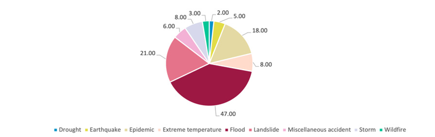
Source: Climate Knowledge Portal, World Bank
While the monsoon rains bring hope of prosperity and life, it also brings foreboding of death and destruction. Every year, continuous and heavy rainfall triggers landslides and floods throughout the country. It impacts impacting thousands of people through the loss of life, property, infrastructure, agricultural yield, and livestock. In the past few years, increased irregularity of precipitation patterns has further exacerbated the impact of monsoon-related natural disasters. In 2021, above-average rainfall caused 144 floods, a significant increase from the 91 floods that were recorded in 2020. The same year, western Nepal observed heavy rainfall and flooding which destroyed thousands of hectares of paddy crops, affecting the livelihoods and food security of the locals.
Why are floods and landslides catastrophic in Nepal?
Increased vulnerability to natural disasters during monsoons is due to both anthropogenic and natural/environmental reasons. Nepal’s naturally steep mountainous terrain and terraced hills combined with the monsoon rains is a hotbed for landslides. Additionally, Nepal’s vast system of rivers and waterbodies makes the country prone to floods. Anthropogenic activities such as mining, tunneling, deforestation, and unregulated construction of buildings also increase casualty during the monsoon season. Unmanaged deforestation has greatly increased landslide risk as it reduces slope stability and increases susceptivity to erosion. Furthermore, haphazard construction of buildings, especially along floodplains, increases infrastructural and social vulnerability to smaller-scale disasters. These anthropogenic factors paired with the natural topography of the country and increased climate change consequences contribute to Nepal’s sensitivity to climate risk and extreme weather events.
Why haven’t measures taken to limit casualty been effective?
Flooding and landslides had been occurring periodically every year for decades yet Nepal has not been able to effectively mitigate and adapt. This can be attributed to the government having a reactive disaster management plan rather than a proactive approach. Every year, the government anticipates the monsoon season and the natural disasters, and every year action against these disasters is not taken until they have already happened. Despite the decades-long program and project funding by various development partners, there does not seem to be an efficient strategized plan at the local, provincial, or national levels. The inefficient response can be attributed to the lack of knowledge and preparedness among government authorities and elected representatives.
A study in 2020 found that a concerningly high percentage of local authorities did not understand the roles and responsibilities of disaster risk management and response under the federal system of governance (Figure 2). The lack of fundamental understanding serves as a challenge for local authorities to efficiently carry out evacuation measures, search and rescue operations, manage information, and provide mass care for victims.
Figure 2: Local authorities’ knowledge on questions asked about disaster risk management and response in Nepal
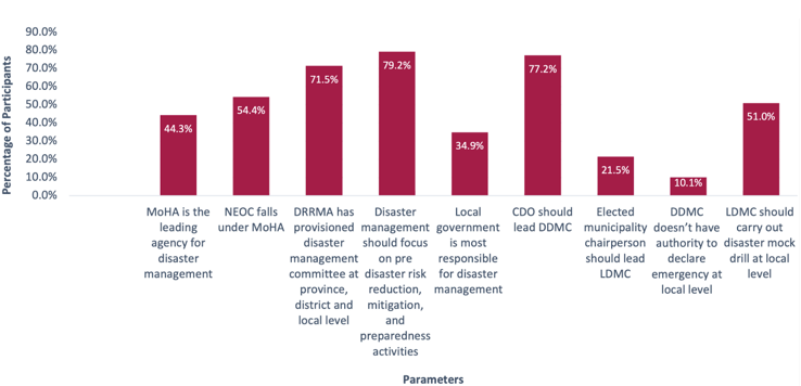
Source: Malla, Shrijan Bahadur, Ranjan Kumar Dahal, and Shuichi Hasegawa. “Analyzing the Disaster Response Competency of the Local Government Official and the Elected Representative in Nepal.” Geoenvironmental Disasters 7, no. 1 (2020).
The lack of proper data is another obstacle for the government in taking proactive action. Despite the annual reoccurrence of the disasters, there is an absence of comprehensive data concerning Nepal’s historical floods and landslides, land surface attributes, vulnerability risks, and rainfall patterns. Nepal’s Disaster Risk Reduction Portal has data only from 2011 of which a lot of information is missing. In the portal, the government estimates “economic loss” for each natural disaster event. However, only a handful of these events have actual quantitative estimations. It is also unclear what “estimated loss” entails as there is no indication of whether it is loss of property, life, or infrastructure, among other possible factors. This hinders the ability to make informed and evidence-based decisions, especially because access to such information could allow for preventative measures to reduce disaster impacts. Nepal’s sparse and scattered data makes it challenging to predict extreme weather patterns and the disasters that follow them.
Way forward
In 2021, the government approved an adaptation-based action plan that addressed climate vulnerabilities and risks in the short, medium, and long term. The National Adaptation Plan (2021-2050) set out priority programs in nine sectors to reduce climate vulnerability and risk. As part of the adaptation plan, the disaster risk reduction and management sector aims to build climate resilience through policy reforms. It will also maintain, upgrade, and strengthen early warning systems and multi-hazard monitoring to allow for climate adaptive actions. Parallelly, the water resource and energy sector aims to bridge climate information gaps and promote climate-informed decision-making. Part of the goal for this sector is to establish a Glacial Lake Outburst Flood (GLOF) risk reduction and early warning systems and construct climate resilient check damns.
In conjunction with government efforts, ICIMOD is working on customizing NASA GSFC’s Landslide Hazard Assessment for Situational Awareness model to develop a landslide mapping and forecasting system for Nepal. This landslide inventory can be used to make data-backed decisions that should improve hazard management and action plans. The model can also generate landslide predictions which can support early warning systems and evacuation. Similarly, the institution has an existing Flash Flood Prediction Tool (FFPT) for Nepal that predicts flash floods for over 12,000 river segments in Nepal. FFPT can be used for flood forecasting, early warning system, and response decisions.
It is imperative for the government to effectively integrate such tools and models into its disaster risk management strategy to reduce the damage and destruction that comes with the monsoon rains. As the annual impacts of climate change intensify, the government must prioritize investment in data collection and analysis at all levels. By doing so, a proactive disaster management system can be effectively implemented before it reaches a point beyond our control.
Karuna Gauchan is pursuing a double major in Quantitative Economics and Environmental Studies at Dickinson College, Pennsylvania. She is currently working as an intern at Nepal Economic Forum (NEF). She is interested in environmental economics and sustainable finance and consulting. Before joining NEF, she worked as an intern at Policy Entrepreneurs Inc. (PEI).